Birder's Eye View

Friday, August 28, 2009

SD Saga: There and Back Again

"We shall not cease from exploration, and the end of all our exploring will be to arrive where we started and know the place for the first time." - T. S. Eliot

The final days of our trip were spent packing, prepping, and driving.

Even though our touring around had ceased, I still managed to see one last life bird on our final day in South Dakota: a Gray Jay! It landed outside our cabin to snatch a piece of stale bread we had thrown out. I couldn't believe my luck! It hung around just long enough for me to get a good visual and identify it quickly, before it disappeared into the ponderosa forest once more.

The next day at the crack of dawn, we loaded up the car and bade farewell to our cozy cabin for the last time.

I had mixed feelings about leaving South Dakota. In one respect, I was happy to be heading home; the traveling life had taken a toll on all of us I think. But in another respect, I knew I was going to miss the Black Hills. I really loved the mountains, crystal clear creeks, hilly meadows, vibrant wildflowers, and clean, pure air. There was something about the Hills that seemed so rudimentary and wholesome.

Back across the Great Plains we drove, through the monotony of golden grasses, down the ribbon highway that stretched all the way to the horizon, and through tiny two-bit towns.

At one point, we passed the town of Lost Springs, WY, whose highway sign reads: "Lost Springs. Elevation: 4995 ft, Population: 1." (A quick internet search later revealed that there are actually 3 people in the town as of this year. Go figure!)

About 7 hours after leaving SD, we made it back to the Colorado Rockies. Although it was mid-August, little patches of snow could be seen from afar on the tops of some of the peaks.

We had a couple hours to spare, so we headed into Eldorado Canyon. It was a gorgeous park, and apparently a popular hub for rock climbers, as well as almost every other kind of outdoorsman you could think of.

We hiked around for a bit, checked out the visitor's center (where I got a really close look at a Broad-tailed Hummingbird at a feeder!) and then finally headed to our hotel in Denver.

That was about the point where I lost my camera. We had gone to dinner at a restaurant near the hotel, and I shoved my camera under the seat in the car, as I usually do to keep it out of sight when I'm not taking it with me.

Well, it had been a very long day as you can imagine, and when we got back to the hotel I completely forgot to pull it out again. When we were packing up at 4am the next morning, I assumed it was already in my backpack, and even thought I felt the strap when I reached in.

Around 7pm that night when I got home and settled in, I went to upload my pictures and you can guess the horror when I realized it was gone. My beloved Olympus SP-560uz 18x Optical Zoom, 8.0 Megapixal digital camera that I got for my 18th birthday was no more.

After a week of calling the rental car company (during which time our car was rented out twice) they finally searched it and did not find the camera. So, someone somewhere has it. All I can say is, I hope they're enjoying it.

Well, I may be camera-less, but the memories from the trip live on. As I finished the last entry in my travelogue, I closed it with an open mind.

Life is amazing. Hard sometimes, but amazing. I love this world, and to have the opportunity to explore even a small corner of it is a true gift.

Until next time,

Happy travels and happy birding!

Labels: , , ,

Wednesday, August 26, 2009

SD Saga: All Mines!

On the 16th day of our trip, we elected to go geocaching again. We only had 3 days left, one of which would be spent packing and prepping the cabin for our departure, and the other two would be spent traveling back to Denver and then home.


The winding road to the trailhead wove in and out of the railroad tracks where the 1880s tourist train ran between Hill City and Keystone. Mountains, valleys, forests, farms, old mines, and meadows could all be seen along the road. It was postcard-perfection.

The trail itself was as beautiful as the drive to it, but much more strenuous. Just a half mile long one way, it ascended about 700 feet up a mountain. It was steep, rugged, densely wooded, and had old car parts and mining equipment sticking out of the ground in some places.

Near the top, we came across an enormous mine shaft-type building towering up out of the terrain like an abandoned fortress. Before checking it out though, we hiked the rest of the way up to find the geocache.

Further up the mountain, we found MORE mines! These were more stereotypical -- big tunnels blasted in the side of the mountain with wooden frames around them. One mine was mostly caved in, and would require some intense crawling, but the other was more open. Mine cart tracks were sticking out of the rocks, twisted and rusted out.

We found the geocache after a bit of searching, and then after rehidingit, we cautiously crept into one of the mines. It was incredibly decrepit, and seemed like a terrible idea to go too far in, so we didn't venture much further than the first room. Rotted wood framing was the only thing between us and several hundred pounds of loose rock crumbling off the ceiling.

Although the mine had apparently produced some gold back in the day, tin, mica, garnet and lithium were much more abundant in these particular claims.

We hiked further up the mountain, and found yet another mine, but this one was visibly flooded out.

Fortunately, we had left the best for last.

As large as the mine shaft building had looked on the outside, it seemed even bigger on the inside. The first floor seemed like some sort of drive-through dumping station, where materials would pour in from big funnels on the ceiling.

After carefully clambering up a set of rotted out stairs, we found ourselves on the second floor. There wasn't much here besides some large machinery and graffiti on the walls.

On the third floor, we found an old workshop, and some interesting, though cryptic, structures. There were gaping holes all over the floor, and many of the boards groaned and cracked under even the lightest step. It was slightly terrifying and awesome at the same time.

Also on the third floor, there were some large chutes with old piles of sand under them. It looked somewhat like the equipment we had learned about in the Big Thunder Gold Mine, days before, but everything here was on a much larger scale.

The mine shaft building went up at least two more floors, each more dilapidated than the ones below it, so we didn't go any further than the fourth level.

Outside, there were heaps of quartz tailings from the mine blasts, piled over 20 feet high and glittering with crystals, mica, tiny garnets, and shards of metal. The entire mountain must have been like swiss cheese with all the mines drilled through it. I wondered how many more could be out there.

It was already well past lunch time, so the hike down on an empty stomach was exhausting. But it had been more than worth it. There aren't many places left where you can spend an entire morning and then some alone on a mountain, wandering through abandoned mines. Like everything else on this trip, it was an unforgettable experience, and one I won't soon forget.

Part 9 will be posted tomorrow.

Labels: , , ,

Tuesday, August 25, 2009

SD Saga: A Trip to the Past

On August 10th and 11th, we explored several well-known historical areas of the Black Hills, ranging from the fabulous Mt. Rushmore, to rough "old west" town of Deadwood.

From the travelogue:

8/10 - Went to see Mt. Rushmore in the morning, which was absolutely breathtaking. One of those things where you always dream of seeing it, and can't quite believe it when you actually do. ... There were workers on top of Roosevelt's head, which made for a unique perspective on the size of the carvings. Altogether, I was simply awed by the whole thing.

The history of Mt. Rushmore was disappointing to learn though. It was named for a New York lawyer, never completed, and the wishes of Borglum (the original sculptor) had never been fulfilled. From what I understood, it was actually supposed to contain an inscription describing what it was, for future generations. During WWII however, construction stopped and it was never completed.

The park was jam packed with hoards of visitors; it was very confusing to navigate, and because maintenance was being performed on the mountain, most of the trails were closed off.

As we were leaving the park, slightly frustrated with the crush-crowd, whiny children, and inconsiderate tourists, I was saying something about how we hadn't even seen Mountain Goats, which were said to live in the area.

No sooner had I spoken, when we came across a small herd of goats right by the path! There was one baby and a few adults, placidly grazing under the shade of the ponderosa pines. I was ecstatic!

The next day, we took a day trip north to the Spearfish area, which, like Mt. Rushmore, had rich and lively history.

We spent the morning at a Western heritage history museum, had lunch by Spearfish Creek (40 degree water! Numbs your feet instantly!), and then stopped by the historic DC Booth Fish Hatchery. I could go into detail about all these, but I think they're fairly self-explanatory, so I'll skip the long descriptions for now.

Around mid-afternoon, we made it to Spearfish Canyon, which is said to be something like 12 times older than Grand Canyon. I can believe that -- the limestone walls looked weathered and the inside of the canyon was forested with lush vegetation.

We explored Roughlock Falls for a bit (pictured above). I had heard that the American Dipper could be seen along Spearfish Creek, but I simply could not find it -- quite likely, I could have been looking the wrong place at the wrong time. Regardless, it was a beautiful area and I'm glad we had the opportunity to see it, even for just a short amount of time.

In late afternoon, we headed back to the town of Deadwood, which, if you are unfamiliar with it, was once the wild west town where gunslingers and lawmen like Wild Bill Hickock, Calamity Jane, Seth Bullock, and others had been established in the 1800s.

Today the town has been turned into a casino strip that thrives on slot machines, saloons, and wild west reenactors and street performers. Fascinating place.

It was quite a day. We saw a diverse mix of the wild and the West, and gained some interesting perspectives on the history of the Black Hills area.

Part 8 will be posted tomorrow.

Labels: , , ,

Monday, August 24, 2009

SD Saga: The Geocache from Hell

After much spelunking and exploring the last couple of days, we decided to take an easy morning on August 8. At the cabin, I took the down-time to do some reading, journaling, sketching, and birding (I had seen over 30 species on the trip so far).

I was quite delighted when a fantastic life bird showed up at the feeders --a Red Crossbill! It hung around all morning, and didn't seem to mind our presence in the least. You could stand literally 2 feet away (for some reason my dad tried to feed it a corn chip, which it didn't appreciate, and promptly vacated the birdfeeders after that).

By noon, thunderstorms were passing through the area, so we went into town for a few hours. By 4pm, the worst of the storms seemed to have passed, so we decided to try a "quick" geocache near our cabin (1.5 mile hike up to a fire tower on a mountain).

From the travelogue:
8/8 - I was pretty enthusiastic at first (yay! let's hike up a mountain!), but then the storm clouds came. We were following a rocky forest road that wound steeply up the mountain and seemed MUCH further than 1.5 miles. I thought we should head back, but everyone else kept saying -- "let's just go a little further, we've come this far" ...for the next HOUR.

Mom and my sister were all gung-ho, but Dad (who didn't want to go hiking in the first place) and I (who was afraid of the impending thunderstorm and our ill-preparedness for such a trek) were less enthusiastic by this point.

Back and forth, up the mountain we climbed, following the switchback trail endlessly. The GPS kept indicating we were 200 feet away from the cache, as the crow flies, but it didn't account for the fact that you couldn't hike straight up the mountain, as the grade was nearly vertical in some points.

Eventually, we got to the top somewhere, we guessed, around 6,000 feet in elevation, with a dizzying vista of the Black Hills. The GPS showed we were now 20 feet from the geocache, but hard as we searched, we simply could not find it.

The mountain top was strewn with lichen-encrusted boulders, rubble from an old fire tower, and scraggly plants growing out of the rocks. It had been almost 2 hours since we started hiking, and we finally decided it was time to call it quits.

Back down the mountain we climbed, cutting the road switchbacks when we could, sliding down through pine needles and jumping ditches to speed up our progress.

Well, the geocache had won this time (although Mom refused to call it a failure, saying that at least we made it to the mountain top and back down in one piece). The whole hike was quite an ordeal, and one I hope not to repeat too often in the future!

Part 7 will be posted tomorrow.

Sunday, August 23, 2009

SD Saga: Beneath the surface

On the 9th day of our trip, we decided to go check out another cave. It was a toss up between Wind Cave and Jewel Cave, so we randomly decided to go with the latter.

From the travelogue:

8/6 - The 1 hour 20 minute tour went down through an elevator over 20 stories below the hill, where the temperature was 49 degrees underground. There were 720 steps on the tour (compared to 180 on the Crystal Caverns tour) but it didn't seem that strenuous. Lights in the cave illuminated fascinating geological features like Nail and Dogtooth Spar, Flowstone, "Soda Straws," stalactites and stalagmites, etc.

Apparently, spelunkers have uncovered about 359 miles of Jewel Cave (which is the 2nd largest cave system in the US), but they think that's only about 3% of its actual extensiveness. Can you believe it? There is even some speculation that it could connect with the nearby Wind Cave, which would mean it's even larger than their estimates.

It all just makes me wonder what else is out there like this that has yet to be discovered.

Jewel Cave had some of the most unique rock formations I have ever seen. Long, glossy fingers stretched down from the ceiling, great statuesque cascades stood frozen all around, and narrow passages spread off in all directions in some places, enticing you to explore them.

After the fantastic tour, we went to check out the natural entrance to the cave, where it had originally been discovered. Like many caves in the area, the story was that it was discovered by the wind rushing out through a tiny crevasse in the side of the mountain. Its discoverers blew the hole wider with dynamite, and were amazed to find the cave extended seemingly endlessly underground.

Indeed, when we found the natural entrance (which was barred off with an iron gate so only park rangers and tours could go through), there was a chilly wind roaring out of it. The wind comes from the difference in pressure inside the cave. When the pressure his higher in the cave, wind rushes out, and when the pressure is lower at times, it sucks in. Awesomeness!

The next day, we explored another type of underground passage -- a gold mine.

Before the town of Keystone was turned into a tacky, overpriced tourist destination, it was a mining town. The Holy Terror gold mine (pictured above, and appropriately named, judging by the looks of the place) was one of the most successful claims there, bringing in over a $1 million back in the day.

We took a tour of the Big Thunder Gold Mine across the street, which had been a complete failure in the 1880s. The miners who worked there spent 30 years boaring 60 feet into the hillside and in the end came out with only 11 ounces of gold (only a few hundred dollars total for 30 years of work).

Nonetheless, Big Thunder was a good introduction to gold mines, and days later we would use what we had learned in a much more off-the-beaten-path situation.

We spent the rest of the day touring around in Keystone. We went to an old antique shop (the longest continuously running store in the town), the schoolhouse where Carrie Ingalls (of "Little House in the Prairie") had been educated, and took a ride down a 2,000 ft long alpine slide.

Despite being a total tourist for a day (and not seeing any new birds), it was all great fun, and eye-opening as always. Travel does wonders for one's sense of perspective!

Day 6 will be posted tomorrow.

Labels: , ,

Saturday, August 22, 2009

SD Saga: Silver City is not a city.

From the travelogue:

8/4 - Went to a beautiful trail in Silver City and had a picnic lunch. Silver City isn't actually a city -- it's a volunteer fire department with a few houses in the woods behind it, and some little kids doing some kind of bake sale there. The trail was amazing though. Thousands of wildflower, a crystal clear creek, pine forests, all running between towering wooded mountains.

After seeing my lifer Black-headed Grosbeak by the creek during lunch, we hiked down a trail for about 30-40 minutes. As we were about to head back, we came across a cave in the side of the mountain! It turned out it didn't go back too far and was swarming with mosquitoes, but it was cool to find, anyhow.

Our next destination was the town of Mystic, where we were planning on checking out part of the Mickelson Trail. Somehow, we ended up getting lost (yes, LOST!) on the two roads in Silver City. We drove about 6 times back and forth past the fire department where the little kids were selling cookies and waving to us every time we went by.

My parents were in a heated argument over whether we should follow the GPS route, which would take us down a terribly rutted forest road for about 8 miles, or go back and take the longer, paved road.

We couldn't figure out how to get back to the main road, so we decided to follow the forest road. It turned out to be so rutted we couldn't drive on it, so we turned around, went back past the fire department (waved to the little kids), and found ourselves at a dead end.

Back at the fire department, a lady came up and said she had seen us "go by real fast a couple times" and figured we were lost. By now we had figured out where we were going, but the road was blocked by a bunch of motorcyclists buying cookies from the little kids. "Well make sure you go slow," the woman warned us, waving us off.

In every vacation we've ever had, we end up getting terribly lost at least once. That was it for this trip. And we made sure to avoid Silver City (which, for the record, I'm sure is a lovely place if it wasn't for our ridiculous experience!) from then on.

The next day, we visited The Mammoth Site, an active archaeological dig that has been enclosed so people can tour and work can be done there year round. It was one of my favorite places yet.

Apparently, millions of years ago the site was a mud pit where mammoths and other prehistoric mammals had slipped in and drowned. In the first 40 feet of excavation, over 55 mammoths have already been uncovered.

It's nearly impossible to imagine the great beasts roaming so abundantly across the land; but to be able to see their actual footprints, bones, and entire skeletons makes it all so real. Absolutely fantastic place!

Part 5 will be posted tomorrow!

Labels: , , ,

Thursday, August 20, 2009

SD Saga: Good times and Badlands

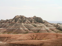
On August 3, we took a day trip out to Badlands National Park, seriously one of the most awe-inspiring environments I have explored.

From the travelogue:

Long day, probably the hardest we've had yet. Drove to the Badlands, about 2 hours away, but took a "shortcut" that took us through 10 miles of [extremely rugged] dirt road, adding about 40 minutes to the trip. It was beautiful though! There were cows everywhere, roaming free [through the mountains]. There were great vistas and wildflowers all over. Lots of birds, but I've found I'm terrible at IDing from the car.

We entered Badlands from one of the smaller entrances, but it was a good choice. The first viewing pullout offered a jaw-dropping, breathtaking, awe-inspiring view of the canyon. It reminded me a lot of Grand Canyon, only it was whitish-gray. Very forboding-looking, and so powerful.

There are simply no words to describe the Badlands, no way to express the unfathomable forces of nature it must have taken to sculpt such terrible and beautiful phenomenon from the earth.

The Badlands are heaven for geologists and paleontologists today, but it must have been hell for the early settlers who came across the prairie to find the land open up to this desolate fortress. It was rather surprising even to drive up to it from the highway!

For all its Godforsaken qualities however, like any desert the Badlands are host to hundreds of species of wildlife and organisms. Rock Wrens could be seen carrying worms and grubs to and fro; we found a dead bat on the canyon floor; and prairie dogs and big horn sheep thrived on the canyon's edge.

Along one drive, we found a large heard of big horn sheep wandering around by the road. I am still fascinated by these creatures. They have absolutely no sense of vertigo, even as they pick their way across narrow ridges hundreds of feet above the canyon floor. Even just standing on a wide rim out over the canyon, I could feel myself swaying.

But these rams are fearless. Even when the rocks gave way, the sheep would just ride the rock slides down to the bottom and continue on from there.

Around mid-afternoon before we headed back to the Black Hills, we took a trek through the canyon; we had only planned taking a quick peek in this one area, but we ended up exploring for nearly an hour (and unfortunately making the stupid mistake of not bringing any water with us!).

It was an absolute blast though. We climbed around on the rocks, followed dry streambeds to where they dropped off hundreds of feet below, and scrutinized the alien landscape.

The terrain was perplexing. Walking along the canyon, you could see that the rocks were little more than hardened mud, though some of the formations were literally as tall as mountains. Yet when you stepped along the ridges, they would simply crumble. It seemed like the entire Badlands would just melt away in the first rainstorm, yet the canyon has been around for millions of years. Life is so amazing!

When we got back to the car, we were pretty well heat-exhausted but it had been well worth it. The Badlands are truly one-of-a-kind. A terrible, brutal environment to live in, but a fascinating one to explore. One of the best days yet!

Part 4 will be posted tomorrow.

Labels: , ,

Wednesday, August 19, 2009

SD Saga: Great explorations

(Note: if you haven't already done so, please read part 1 first)

After a 3 hour drive from Torrington, WY to the Black Hills of South Dakota, we decided to spend the afternoon caving, and go to Custer State Park the next day.

From the travelogue:

7/31 - Visited a place called Sitting Bull Crystal Caverns -- skeptical at first, it looked really touristy, but it turned it to be really cool. We had to climb 103 feet down a cold, narrow, vertical staircase, which I wasn't crazy about. But the caves were amazing. Afterward we hiked a trail behind it for a bit... saw my lifer spotted towhee too!

The caverns were indeed, spectacular, and boasted some of the largest Dogtooth Spar in the world. It was a good introduction to SD caves, but would be dwarfed by Jewel Cave, which we would be exploring later in the trip.

The next day, August 1, we did a lot of hiking and driving. First we hiked to the top of the mountain where we were staying. The view was unbelievable, and apparently it was the only place for miles around where you could get cell phone reception (not that we needed it, but occasionally you'd find people at the top listening to their messages or making a phone call!).

After then visiting Crazy Horse monument (which was amazing!) we headed to Custer State Park. Unfortunately, it was the beginning of the Sturgis Motorcycle Rally week in SD, so the winding mountain roads were bogged down with literally hundreds of thousands of motorcyclists.

Regardless, I think I saw more wildlife at Custer than I've ever seen in any other state park. We saw pronghorn, bison, big horn sheep, chipmunks, prairie dogs, deer, and more.

Custer also has a population of "wild" burros. They're actually the feral descendents of a group that was used to carry visitors to Harney Peak in the 1920s. Since they are no longer used by the park, the burros formed herds and have been breeding and living wild ever since.

Well, as "wild" as a burro can be... they seem to have learned that if they hang out by the road, they get free handouts by tourists.

Another cool wild critter we found living in a Prairie Dog town was this 13-Lined Ground Squirrel. Never seen one of these before, and didn't expect to, but it was pretty fun to find!

In the first five days of our trip, I had seen 21 species of birds. I got up early one morning to go birding around the mountain, and saw my lifer Red-naped Sapsucker and Least Flycatcher. I also found lots of wild turkeys, American robins, Red-breasted Nuthatches, and Black-capped Chickadees. A Ruby-throated Hummingbird even came to check out the birdfeeders hanging around the deck of our cabin, but didn't stay for long upon discovering we didn't have any hummer feeders.

So far, the trip was going well. We had seen a ton of birds and wildlife, some breathtaking scenery, and fantastic geology and ecosystems in the Black Hills.

Part 3 will be posted tomorrow.

Labels: , , , ,

Tuesday, August 18, 2009

SD Saga: Rocky Mountain High

I am back from my 19 day excursion in the mountains and Great Plains -- exploring Colorado, Wyoming, and South Dakota. Despite several mishaps (injury, illness, and losing my camera on the very last day!), the trip was amazing and a total eye-opener. Fortunately, I still have my travelogue and my mom's photos, so with these I shall enlighten you to the journey I've been on for these past two and a half weeks.

From the travelogue:


7/30 - Birds seen today: Dusky grouse, stellar jay, barn swallow, tree swallo, black-billed magpie, Western tanager, common raven, redhead, dark-eyed junco, and Northern shrike. At around 7:45am we headed into the Rocky Mountains. Dad wanted to take us to some place he'd been before, but the cold front caused intense fog (and 40 degree temperatures!) to fall over the mountains, obscuring all but the closest peaks. It was nonetheless impossibly spectacular -- impossible to fully comprehend the power of nature that had created such a breathtaking and literally unbelievable environment. We got all the way up into the mountains (10,000 feet or so) until the fog was so dense you couldn't see anything. It was terrifying to be driving along cliffs with nothing but whiteness below.

Temperatures were numbing (especially after coming from 98 degree FL weather!) , and it hard to see anything through the fog. Nonetheless, the Rockies were absolutely stunning and I came to understand the meaning of "Rocky Mountain High."


The wildlife was as exciting as the scenery -- stellar jays (life bird!), magpies and ravens could be seen from the roads, even through the fog. Chipmunks scurried about, and at one stop, I even saw my lifer broad-tailed hummingbird! I got some fantastic photos of it, but of course my camera gone now. :(

There were tons of Redhead ducks at one pond as well, all huddled against the freezing wind.

Later in the day, the fog cleared a bit, opening up to a grey sky. We stopped at Alluvial Falls, the result of a giant flood in 1982. It's hard to tell the scale of the waterfall, but you can see tiny people in the picture above. We climbed about halfway up for a bit, which was great fun.

At Alluvial Falls, I got my lifer Western tanager and Dusky Grouse! I have never seen any type of grouse before, so it was quite a surprise to find this one and a juvenile sitting right next to the trail, clucking and preening contentedly.

Eventually we had to leave CO and drive to our hotel in Wyoming. The drive out of Rocky Mountain National Park was inconceivably beautiful, despite the weather. I was amazed when we got out of the mountains to find the landscape immediately transform to a dry prairie environment. It was as if I had blinked and all the stunning glory of the mountains was suddenly gone.

For the next 170 miles or so, we drove through a fascinating monotony of dry, grassy hills and farmland. The ribbon highway stretched all the way to the horizon, sometimes with no cars to be seen in front of us or behind us.

Everything was so huge. The sky was like a giant swirly blue bowl over us, and the land was a hilly brown prairie sprinkled with cow herds and pronghorn. Our stopover was in Torrington, a tiny little town that we made sure to avoid on the return trip.

Thus ended our first full day in the Great Plains. A lot of driving, amazing sights, and a fantastic experience.

Day 2 will be posted tomorrow.

Labels: , , ,